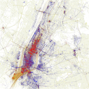
Locals vs tourists map by untapped cities and Eric Fischer
Tourists are red, New Yorkers are blue. Locals vs tourists map by untapped cities and Eric Fischer.
Eric Fischer, self described as a "geek of maps, data visualization, failed transportation plans of the past, history of technology, computers, pedestrianism, and misspelled street signs," takes photos of cities and makes maps and other visualizations with many sorts of urban data.
This map is part of his project 'A Geotaggers' World Atlas' in which he uses data from the public Flickr and Picasa search APIs to map where photos have been taken in different cities. "Some people interpreted [these maps] as... maps of tourism." So, Fischer made the series "Locals and Tourists" to test this hypothesis.
"Some cities (for example Las Vegas and Venice) do seem to be photographed almost entirely by tourists. Others seem to have many pictures taken in piaces that tourists don't visit." He reports.